 The Grand Canyon Rim to Rim to Rim (a.k.a. R3) Hike/Run
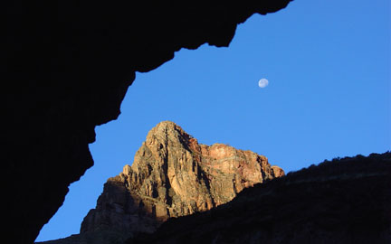
Introduction Having read trip reports on 14erWorld.com from Bob Dawson and Kurt Traskos about this endeavor along with hearing Aron speak highly of his trip like this, I was quick to respond with an enthusiastic yes to an e-mail inquiry from Sean Cunniff in mid-October asking if Bill and I would be interested in joining him on this hike in mid-November. I had never been to the Grand Canyon and thought this long endurance hike would be a fantastic introduction to this magnificent wonder. For those unfamiliar with the "Grand Canyon R3" the hike starts on the South Rim of the Grand Canyon at 6,860' and descends the canyon via the Bright Angel trail to the Colorado River at 2,400'. From there the hike goes up the North Kaibab trail to the North Rim of the Grand Canyon at 8,200' before returning back down to the river and up the South Rim again. No doubt it's a tough hike but an absolutely great "Tour de Canyon" and an awesome way to see the canyon. Friday, November 18th Bill and I left Los Alamos in the late morning to meet Sean at his office in Albuquerque at 2:00pm. Neither Bill nor I had hiked with Sean in the past but I had a very favorable opinion of his personality and hiking ability from reports he has posted in the 14erWorld.com forum. Sean had done this R3 hike solo a couple of times prior to this trip so we relied on his opinion and information to prepare for the hike. We all piled into his car and drove the four hours on I-40 to Flagstaff that afternoon. My mom and her husband were in Flagstaff that night after visiting the Grand Canyon that day for their anniversary so we met them for dinner at the Beaver Street Brewery before driving further north to Tusayan, AZ that night. Tusayan is the nearest town to the South Rim and is only about ten minutes from the park. We camped in the national forest just south of Tusayan that night going to bed around 10:30pm. Saturday, November 19th It was a cold morning at 2:40am with the thermometer reading 19F but we coaxed ourselves out of the warm sleeping bags, dressed and drove into the park. The nice thing about driving into a National Park at 3:15am is the entrance stations aren't staffed and you can get in for free! Sean parked the car in a parking area designated for overnight hikers near the Maswick Lodge and we walked a short distance to the Bright Angel TH. At this point I got my first view of the Grand Canyon illuminated by the bright moonlight and was awestruck. The thing is gigantic! How cool to have my first view of the canyon in moonlight! The side benefit of this was that I couldn't really tell nor fathom just how far down and over we'd have to hike to reach the North Rim. :) At 3:45am we left the canyon rim for the slow but steady descent by headlamp and moonlight down to the river. The trail was much wider than I had anticipated and also in surprisingly good shape despite the fact that many mules descend and ascend this trail daily. The signs of mule wear and tear were obvious though and we had to watch our step to avoid loose rocks and poop. 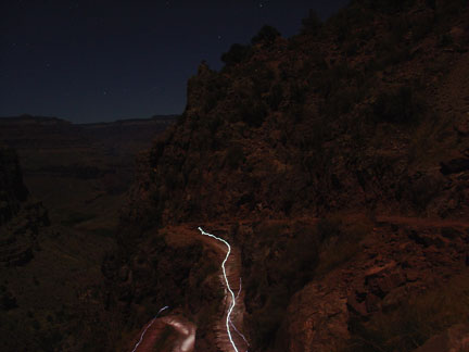 Descending the Bright Angel trail in the bright moonlight. It was a cold descent involving tons of switchbacks but it sure was nice to start a hike out with descent instead of ascent. However I did think about how "fun" it would be to ascend this trail later. While the moonlight helped me get a decent view of the surroundings I was wishing I could see this part of the South Rim in sunlight. But that would not be because by the time we got back to his point it would be dark again. D'oh! At 5:00am we reached the Indian Gardens and stopped for a bathroom break at the composting toilets before continuing down in the dark. We reached the Colorado River at Pine Creek Beach at 6:03am still in complete darkness. Hiking east along the Colorado River towards the Silver Bridge at Bright Angel camp was enjoyable. Because I was taking many 30-sec exposure photos I was behind Bill and Sean quite a bit and turned off my headlamp to hike this section by moonlight. The moonlight combined with the silence broken only by the sound of the river made for a surreal hiking experience. Just beautiful! We actually encountered two backpackers heading up and a group of Japanese hikers heading out as well on this section of trail. At 6:25am we came to the Silver Bridge spanning the Colorado River over to the Bright Angel camp/Phantom Ranch area. 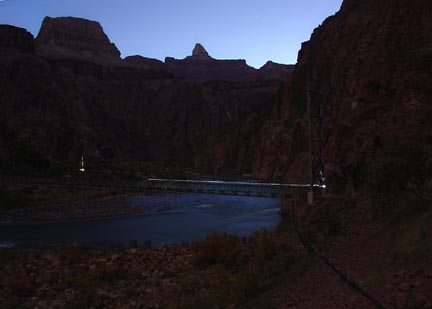 Crossing the Colorado River on the Silver Bridge. (It was still fairly dark; this is a 30-sec time exposure) At the Phantom Ranch area we refilled our water bladders, ate some food and took a short break. We also helped a guy who was looking for the Bright Angel trail so that he could "go home". From here we hiked north on the North Kaibab trail through Phantom Ranch. I could smell waffles being cooked and felt a slight (OK, severe) wave of jealousy of the campers there about to chow down on those waffles. We also saw a couple of turkeys perched atop a satellite dish at the ranch. Craziness. The initial section of trail here out of Phantom Ranch going up-canyon passes through a deep rock gorge and crosses the Bright Angel creek at least four times on nice bridges. The trail is also very smooth and gentle for the most part so we were all looking forward to running a bit on this on the return. As we hiked through the gorge and out into more open terrain we could see the early morning sunlight illuminating the tops of the upper cliffs and had a view back to the South Rim. Damn we had covered some ground already! Around 9am we passed through the Cottonwood Camp and took another toilet break there. The water was turned off, as we had expected, so we carried on for about another 30 minutes to the Roaring Springs pumphouse camp at 9:30am. From here we'd have to hike 7 or so miles to the North Rim and back down to here for more water so we filled our water bladders up nearly to the rim. We still hadn't yet hiked into any direct sunlight and I was a bit chilly. My fingers, in particular, were quite cold and I had a hard time using my left thumb to open my water bladder. I did eventually succeed and couldn't wait to get into the sun! The Cottonwood trees here were in their fall colors making for a beautiful scene of desert red rock and yellow tree leaves. We carried on up the nice trail where we soon were engulfed by direct sunlight. I continued to hike in my black running tights and long sleeve shirt for a while to warm up before changing out of those clothes at the Roaring Spring. Roaring Spring is a large spring flowing directly out of the side of the canyon wall down into Bright Angel creek. Very nice. 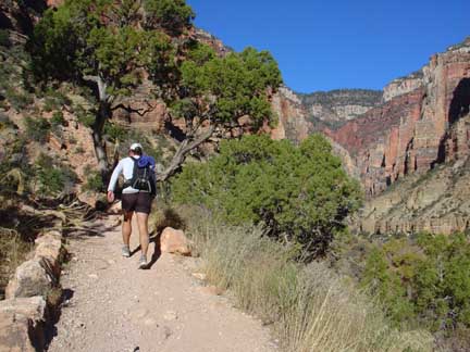 Sean hiking up the North Kaibab trail along Spring Canyon. The North Rim can be seen in the background. This section of trail up to the North Rim was extremely beautiful and my favorite portion of the hike. (This is an unfair statement; as I didn't get to really see the Bright Angel trail portion of the hike as it was dark.) The green and yellow leaves of the Cottonwoods along Bright Angel creek contrasted nicely against the dark red sandstone of the lower canyon and the white Coconino sandstone of the upper canyon. Simply stunning. And with each step up the view to the South Rim increased as well. Along this portion of the trail we passed a solo hiker taking a break. As we talked with him we learned he was also doing the R3 hike. He then asked us where we were from and I said, "Albuquerque and Los Alamos, New Mexico." He said, "I'm from Los Alamos too!" Blown away I introduced myself and then we recognized each other from a hut trip to the Jackal Hut we had done earlier this year with a mutual friend. Wow! This was damn ironic. So we hiked with Thomas the rest of the way up to the North Rim arriving at the rim at 11:55am. At the parking lot at the North Rim I wasn't too particularly impressed as you can't really see the canyon due to a large number of pine trees. Sean explained to us that we could hike another 1.5 miles or so to the North Rim visitor's center but that it was closed this time of year. Next time I'll check that out. It was significantly cooler than just below the rim so we sat and snacked for a short bit before deciding to hike back down the short distance to the Coconino Overlook where it promised to be warmer and with a better view. Here we bid goodbye to Thomas as we planned to run a fair bit of the trail back down to the river and he wasn't interested in that. The Return to the South Rim We departed the North Rim around 12:20pm and moved well down to the relative warmth and significantly better view of the Coconino Overlook. 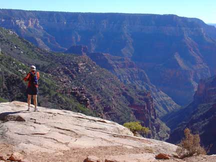 Bill enjoys the view towards the South Rim from the Coconino Overlook just a short distance down from the North Rim. Here we again rested and enjoyed the view. Sean and I managed to nearly fall asleep splayed on the warm sandstone in the direct sunlight before Thomas passed by on his way back and said, "Hello again." This prompted us to get going again with Bill leading the way. Something got into Bill here and he started jogging down the path. Sean and I decided this would work and started off behind him. Before we knew it we were back at the bridge crossing over the side canyon where Bill had waited for us. He again began a quick trot and we again followed suit. We passed another solo hiker on his way up and then pass his partner on his way down--they were camping at Cottonwood Camp that night and the guy going down didn't feel too well. We soon lost sight of Bill as Sean and I walked the small uphill sections while Bill continued to run. Around 2:00pm we reached the Roaring Springs pump house where Bill was waiting for us. Here we filled up with water again, snacked and carried on. The Cottonwood trees surrounding the pump house where nicely illuminated by the sunlight and I lamented the fact that we had to keep going. Bill again took off swiftly when Sean and I tried to keep up. Along the descent about a half mile above the Cottonwood Camp we stopped to enjoy a small waterfall with a tempting swimming hole. None of us took the bait though so I just photographed it and we carried on. 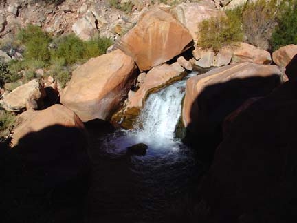 The nice waterfall with a great swimming hole. Had it been summer I would have definitely taken the plunge! From here on out Bill picked up the pace somehow finding some awesome energy and basically left Sean and I in the dust. I'd like to say that my emergency bathroom break at Cottonwood Camp was the reason I couldn't keep up but really Bill was just on it! For the next hour and a half Sean and I trotted along at a fair clip but never caught sight of Bill again until we reached Phantom Ranch at 4:00pm. Bill even had time to stop and leave us a rock note on one of the transcanyon waterline manholes. 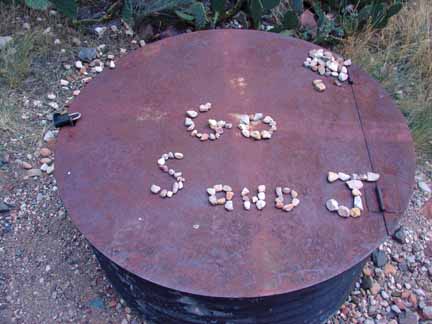 Bill's encouraging message to Sean and I. While I'll admit this was somewhat encouraging it was strangely discouraging realizing he had time to do this and we still hadn't seen him in over an hour! Once back at Phantom Ranch I could smell the deliciousness of food being cooked for the campers and was jealous. I took comfort in knowing, though, that in about 5 hours we'd be back on the South Rim and would be seeking out food of our own. We found Bill relaxing and munching some snacks at the Bright Angel camp where he had been for about 15 minutes already. Here we took a leisurely break of about 40 minutes snacking, drinking from the water spigot and resting with our legs elevated above our heart to get the lactic acid out before charging up the remaining ~9 miles and ~4500 vertical feet of the seemingly never-ending switchbacks of the Bright Angel trail. Well, it was time and at 4:40pm we mounted up and headed across the Silver Bridge and back along the Colorado River discussing the water rights of downstream cities, towns and countries. Let's hope Mexico is getting the quality water we promised it. At 5:10pm we reached the turn at Pine Creek beach and took in the view of the last light of the day barely illuminated the top of a neighboring tower. 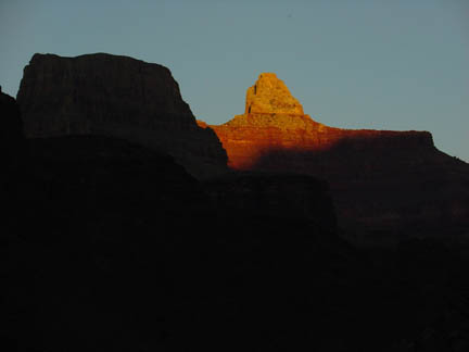 Sunset view from the Colorado River looking easterly. From here darkness slowly encroached on us but we managed to make good time and effort up to Indian Gardens by 6:15pm. We barely reached Indian Gardens without needing our headlamps but it was pushing it. Another lengthy break and water refill and we enjoyed the view of the plethora of stars above in the clear, calm sky before heading up for the final push at 6:30pm. The switchbacks and gain up the trail were disheartening and was definitely testing our will and physical strength. "Should we have ran that much earlier," I asked myself? "This is damn tough, I hope I can make it," I thought. Alas, we had no choice but to carry on. "Just think of the food, the hot chocolate, the warming sleeping bag--all of that awaits you at the top." We stopped for one last break about 1.5 miles from the rim at an unnamed warming/rest shelter or something that had stairs and a chain railing leading to it. (Jason's thoughts) Alright, let's finish it off. I'm never doing this again, but just go. RFM, RFM, Relentless Forward Motion, just keep moving forward and up. Passing through a tunnel--almost there. One more tunnel and we'll be there. What's that light over towards the North Rim? Ah yes, the moon. We started in the moonlight, we'll end in the moonlight. It's an awesome sight, I better take a picture. 30 second time exposure taken, that should be good. Is that the sound of a car or truck, why yes it is! The tunnel, holy crap, the last tunnel! Almost there, hell yeah! Carry on, carry on. The trailhead sign above, we're there. This wasn't so bad, I could do this again. Yeah, maybe even more efficiently and faster next time. Yeah, that's the ticket! We're there! It's 8:49pm and we're back. Sweet! "It's Miller Time fellas," said Sean. Indeed it is! All three of us did the high-five thing symbolic of kicking some ass or something and thanked each other for the fantastic experience. Hiking with Sean was a true pleasure as he's a very tough individual with a positive attitude and great sense of humor. I think all three of us hiked well together and share a very similar hiking ability. It couldn't have worked out better! 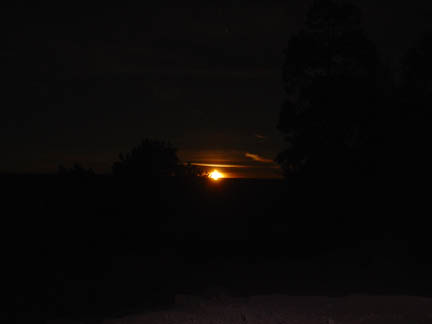 The rising of the moon on Saturday night signified the end of our Grand Canyon rim to rim to rim hike. What a way to wrap up the wonderful day! Back at the car we discussed options while we plowed through a new can of sour cream and onion Pringles washed down with Coca-Colas. We opted to drive to Flagstaff for a late night Denny's meal and then camp in the national forest just north of Flagstaff. Sean mustered up the energy to pull off the driving while Bill and I intermittently dozed off in the warmth of the car. After consuming some fine Denny's food we found a camp and hit the bags around 12:30am to sleep soundly for 9 hours before making the drive home on Sunday. Written by Jason Halladay on 21 November 2005.
|