Friday, 6/25:
We left Los Alamos at
4:30 en route to Flagstaff,
AZ to camp in the Coconino
National Forest and hike Humpheys Peak the following day.
We arrived at Flagstaff around 11:30. Our drive had been uneventful
save the gawdy fake animals and people adorning the cliffs as
you enter the state of Arizona from the east on I-40. We passed
the turn off to Meteor Crater on the way and vowed to see it on
the way home. We didn't get to see it on the way home but more
on that later.
Saturday, 6/26:
We awoke at 7 a.m., drove to the nearest gas station to fill our
water bottles and grab a frozen burrito for breakfast. Erica opted
for something a little less "gut-bomb-like" and we started
the very short drive up to Arizona
Snowbowl ski area (14 miles or so out of Flagstaff). The trailhead
for Humphreys Peak starts from the lower parking lot at the ski
area. It was going to be a warm day we could tell already. We
started hiking at 9:30 am ready to tackle the four miles and 3,300
ft. elevation gain. The hike starts by crossing a ski slope. The
trail is in good condition and reaches treeline at about 11,100
feet. Once we reached the 11,800 ft. saddle between Humphreys
Peak and Agassiz Peak we were getting chilled by a strong, steady
wind of 15-20 MPH. The day was warm but we were chilled by the
constant wind. We donned our rain jackets and continued up the
rocky, steep trail to the summit. We reached the summit in two
and half hours. Humphrey's offers a
great view of northern Arizona including a view to the Grand
Canyon 50 miles to the north. We took some photos, ate and headed
down in the strong winds. The sky was partly cloudy but still
a beautiful day. It took us the same amount of time to descend
the trail as it took us to ascend the trail because of heavy usage.
We would walk five minutes, step aside for an upcoming party,
repeat. Very busy trail. All in all, it took us a little over
five hours to make the roundtrip hike. We went into Flagstaff,
watched the Adam Sandler movie, Big
Daddy, and continued our drive towards Lone
Pine, CA and the Cottonwood
Lakes Trailhead. Six hours later We were too bushed to continue
driving so we found a desert road north of Barstow,
CA and camped. The moon was nearing full and illuminated the
desert making for a nice sight.
Sunday, 6/27:
We completed the drive to Lone Pine by 9:30 am. I stopped at Carl's Jr. for my last bit
of good 'ol greasy fast food for a few days and consumed a breakfast
crossiant with bacon. Erica had tater tots and OJ. Full of quality
food, we drove the amazing 20 miles of the Horseshoe Meadow Road
to the trailhead in the Inyo
National Forest. Horseshoe road rises from Lone Pine to the
trailhead at 9,000 ft. via some scary switchbacks. The road is
paved but rocks and dirt are very prevalent on this road due to
its location and terrain. We arrived at the
trailhead and started hiking at 10:30 am ready to tackle 42
miles of hiking in the next four days. I had made reservations
for this trail back in March. The trails in this area are so popular
groups must pay a minimal $4.50 fee per person to hike the trail.
The trails are quota trails and are limited to a certain number
of hikers a day. Our goal for the day was to hike 9 miles and
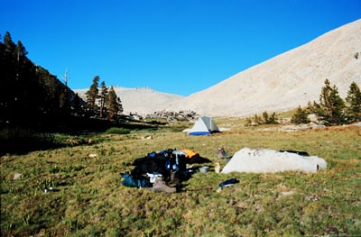
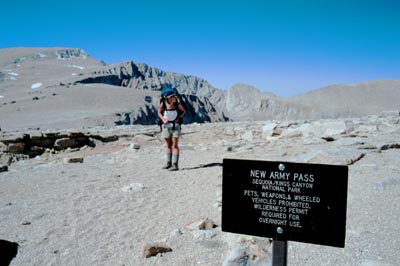
cross New Army Pass (11,475). We reached our goal around 6:00
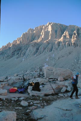
pm after hiking through some very hot desert terrain and setup
our
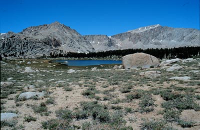
first camp. The
Cottonwood Lakes were beautiful and teeming with tiny California
Brown Trout. New
Army Pass was a bit of a hump being so hot and steep. We encountered
a short, 20 ft. section of snow at the top of the pass but it
was easily negotiated. We had ice axes with us at the word of
the ranger station. They had said the trails were covered with
snow and recommended ice axes and crampons. As it turned out we
didn't need them at all. We cooked instant
refried beans and chowed on bean burritos. After we feasted,
the mosquitos decided it was their turn to gorge themselves. We
had bug repellent, Green
Ban, (which I highly recommend), but that only kept them from
biting. They were still damn annoying. TAKE INSECT REPELLENT!
We retreated to the tent early to read and sleep after a long
day.
Monday, 6/28:
Awakening by 8:00am, we layed around for a bit before actually
getting up. We had plenty of time to reach our next camp, Crabtree
Meadow. The 11 mile hike to Crabtree Meadow was going to be
tough but we could take our time. I got up as the sun was just
peaking over New Army Pass and took a photo
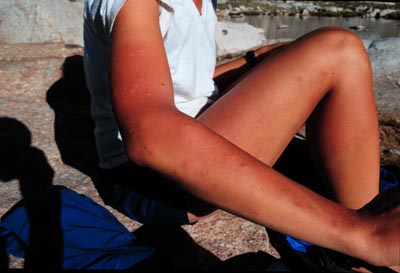
of a little tarn in the sunlight. Before packing up we assessed
the damage the mosquitos had inflicted on
our bodies the previous night. It was not a pretty sight and,
little did we know, was only going to get worse in the next day
or two. We packed up and began the descent to Rockwood Patrol
Cabin 5 miles away. In a few hours we were there and ready for
a break. The cabin, although slightly difficult to find, was a
work of art. I found myself wishing I could live there. It is
built right next to the raging stream, has a propane stove on
the front porch, solar panels for power and a nice peaceful porch
overlooking the stream. It was here Erica and I decided to take
a dip in the stream, cool off and clean up a bit. Cold but refreshed
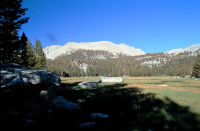
we started on the remaining 6.7 miles to Crabtree Meadow. This
was another hump coming out of the valley up to Guyot
Flat. Hot and desert terrain kept us sweating and dreaming
of the high mountain lakes we would find near Crabtree Meadow.
Since passing the Cottonwood Lakes we had not seen anyone else
on the trail. Once we reached Crabtree Meadow that all changed.
As we hiked up to the meadow, 9 hours since leaving our camp near
New Army Pass, we could see that we were no longer alone. Large
groups were camped all along the meadow. We opted for a nice,
open
campsite right above a raging waterfall. We again dipped into
the river, ate, explored the meadow area and settled in for the
evening by reading some more. During our exploring we had a met
a group of seven teenagers and two adults out on a church group
hike from Utah. After talking to them we discovered they had the
same plans as us--Hike to Guitar lake the next day, get to bed
early and ascend Mt. Whitney by the light of the full moon. Although
never spoken, it was apparent we would awaken a bit earlier in
hopes of summiting Mt. Whitney before this large group of nice
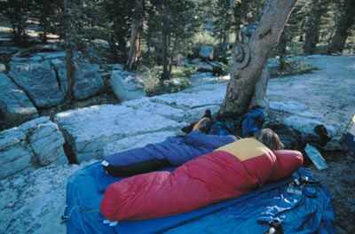
folks. We relaxed under the completely clear sky and pondered
the fact that we had not seen a single cloud since Kingman,
AZ. Hot, dry and clear. These conditions, coupled with a lack
of mosquitos near the river, allowed us a great night's sleep
out under the stars listening to the constant white noise of the
waterfall. We slept very well that night.
Tuesday, 6/29:
We took our time in getting up and packing up for the hike on
this day was only a mere 6
miles to Guitar Lake. By the time we had set out for Guitar
Lake, the others in the meadow had already left. We hoped for
a good campsite despite being last to leave the meadow. By 10:30
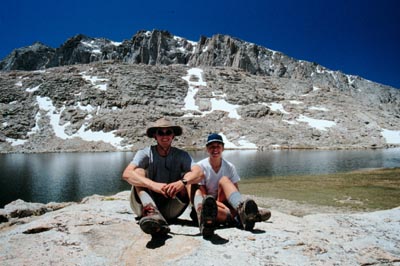
am we were nearing Guitar Lake. We came around a corner to see
a lone pack sitting on the trail with no one around. We heard
the voice of the pack's owner from behind us. A friendly chap
named Stuart was the owner of the pack. Stuart was from London
visiting the states for a few weeks. He had started from Kings
Canyon National Park and was working on a 72 mile hike culminating
in the summitting of Mt. Whitney. He was a very nice guy and kept
us company the remainder of the hike to Guitar
Lake. At Guitar Lake we chatted a bit more. Stuart was going
to camp there and we planned to go a bit higher, to Hitchcock
Lakes, so we could have a head start on the Utah clan. We
found a nice shelterd spot above treeline at about 12,000 ft for
camping
that night. After unloading our packs we took the short jaunt
down to Hitchcock Lake and once again, swam and bathed. The temperature
was an amazing 80 degrees so the icy cold water felt quite nice.
(Still a little too cold to sustain long swims though!) Erica
was the brave one and completely submerged herself in the lake.
I opted for the whimpier wade into the waist and dip the head
maneuver. We rested and enjoyed a very lazy afternoon by the lake.
This lake was perhaps the most beautiful high lake I have ever
seen. Framed by steep, rocky cliffs on the south side and a wide
open view of the sky on the west and north side, it was extremely
picturesque. Three hours later we decided to head back up to camp
and hit the sack for our early 1:30 am awakening the next day.
Once again, we were able to sleep out under the stars and the
bright moon.
Wednesday, 6/30:
The watch alarm sounded at 1:30 am. I had slept a fairly restless
night in anticipation of the summit of Mt. Whitney. We coaxed
ourselves out of our nice warm sleeping bags and packed up to
hit the trail by 2:00 am. The moon was bright--really bright!
It was brighter than any moon I had ever seen. We could look at
it but not for too long as it was too bright to stare at. A white
sun. This made for great trail illumination and route finding
which was nice. After about 45 minutes of hiking we looked down
and noticed a bunch of aqua-green lights bobbing up and down.
It was the Utah group. They had awakened 10 minutes after us.
We knew this because they set off a firecracker that echoed like
nobody's business through the basin shortly after we had awakened.
On the very steep switchbacks up the west side of Mt. Whitney
I stopped for a two minute time exposure at f2.8. This
photo turned out wonderful, making night look like day. It
was a couple hours before we made it to Trail Crest. From Trail
Crest it was another 1.9
miles to the summit. The Utah group was gaining on us. We
left our packs here since we would be coming back to this point
before dropping off the east side of Whitney back to the Whitney
Portal. But now, we had another 1.9 miles to the summit! We grabbed
our daypacks and headed up trying to beat the sunrise. There was
a couple spots of kinda spooky exposure that was made a bit more
scary by the moonlight. One hour later we were there! The sky
was full of pastel colors as the sun began to peek out over Death
Valley. It was windy, damn windy, and cold on the summit.
Erica and I had parkas, mittens and hats but the gang of Utah
hikers were in pullover sweatshirts and jeans and freezing big
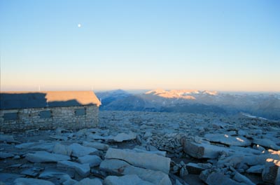
time! They found shelter in the summit
cabin while Erica and I braved it out sitting peacefully watching
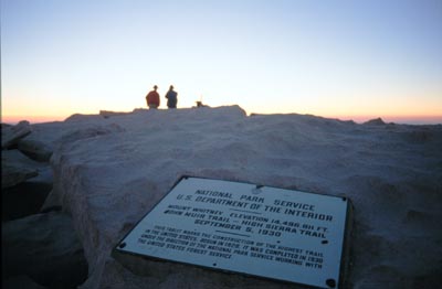
the sunrise. Many photographs were snapped, the register signed
and food consumed before we headed back down the mountain an hour
after we had reached the
summit. We still had another 11 miles to go to reach the Whitney
Portal trailhead. By this time I was craving the greasy fast
food of Carl's Jr. or Dennys.
(On the drive out we passed numerous Dennys' and it had me thinking
about an omelette with bacon the greater part of the trip!) The
cuisine the past few days had consisted of freeze dried meals
and trail mix. I put thoughts of food aside, we were still 9 miles
from the trailhead and then we were going to have to hitchhike
to get back to where my truck was, so greasy food was many hours
away. We prepared to lug our 50 pound packs down the notorious
two miles of switchbacks from trailcrest down the steep section.
However, it was then that we spied a 300
foot long section of snow perfect for glissading down. We
had lugged the ice axes over 28 miles of trail and damned if we
weren't going to make good use of them now. We donned our outerwear,
secured the packs to our backs and went sliding. This was not
only fun but saved our knees from two miles of hard impact. The
remaining seven miles was hot and painful on the knees and feet
and I was glad to see the parking lot by 1:30pm. After coming
down the Whitney Portal trailhead I couldn't believe people were
hiking up it! It's a steep and hot trail and perhaps I was a bit
biased after hiking 30 some miles. When we reached the portal
trailhead we took time to explore the general store full of souveniers
and guzzled down all the free-refills-root beer we could drink.
The store owner said he was headed down the road in about an hour
and we could hitch a ride down with him. We had hiked out with
the Utah group and they were in the same boat--they needed a ride
to thier van at the Cottonwood Lakes trailhead as well. It was
nice to have the company trying to get a ride. The store owner
flaked on us so we took matters into our own hands. It wasn't
until two hours later that I caught a ride down with a German
fellow to the Horseshoe Meadow road turn off. He wasn't able to
drive me the remaining 20 miles to my truck. I was now in the
desert in 105 degree weather burning up looking for another ride.
One of the Utah group's leaders had found a ride to this point
as well so we had each other for company while looking for a ride.
A couple people stopped but no one was going all the way up. It
was looking bleak and I was roasting. About the time I had given
up hope for a ride and resigned myself to hiking the remaining
20 miles, Erica and the other Utah group leader pulled up in a
bronco with one of California's
finest, a CHiP! This particular officer had been living and
working in the area for over 20 years and knew his stuff. He was
a regular tour guide showing us where movies had been filmed and
where cars had driven off the Horseshoe Meadow road. Quite the
gentleman and friendly officer. We reached the truck and were
relieved to be back but very excited about the trip we had just
completed! It was one of the best backpacking trips I have ever
been on. Beautiful country, nice weather and the highest peak
in the lower 48 states, I was elated.
We were exhausted, dirty and hungry. Where could we go to get
cleaned up and have some fun? Magic
Mountain was the winner! We drove the 270 miles to Valencia,
CA that afternoon, got a hotel room, cleaned up, and went
to feast at Applebees!
The next day was a bit of culture shock going from the complete
solitude of the sierra wilderness to total inundation of people.
We enjoyed ourselves none the less. We rode all the great coasters
until 6 pm when we began our drive home. We pushed hard to reach
Flagstaff by 2:30 am and camped where we had camped on the way
out to California. On Friday we continued the drive home, stopping
at Meteor Crater
to satisfy our curiosity about this wonder. When we arrived we
learned it was eight dollars a person just to view the crater.
We were short on cash and wanted to eat at the Cracker Barrell
in Gallup,
NM, so we opted not to pay. We had spied a dirt road on the
way in and hoped we could drive that out a bit and hike to the
crater from there. Turns out they have a security guard patrolling
this road and he won't allow you to hike out from your vehicle.
We didn't get to see the crater. The rest of the drive went smoothly
and we arrived in Los Alamos by 5 pm in time for the fourth of
july weekend.
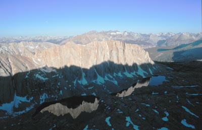
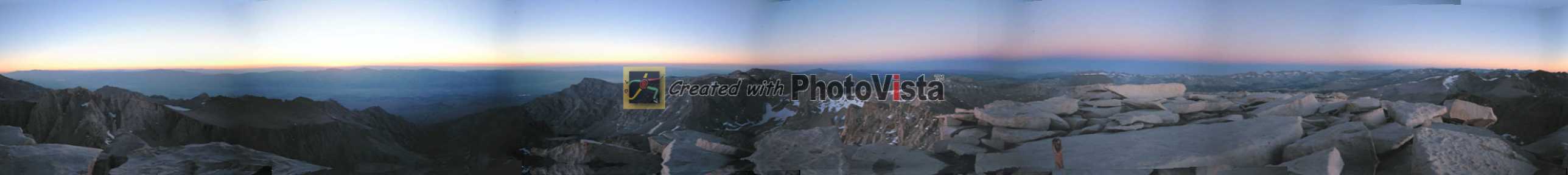
A
panorama photo from the summit of Mt. Whitney.