 Culebra Peak, CO (14,047') and Red Mountain, CO (13,908') a.k.a. Operation Dark Snake III
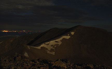
Saturday, July 23rd Bill and I departed Los Alamos around 7am. Getting to the east side of Culebra Peak is kind of a pain and there's not really an easy way from Los Alamos. So we drove south to Santa Fe to catch I-25 north to Trindad. After stopping for breakfast burritos at the Santa Fe Baking Co. we were finally on the interstate at 8:30am. We drove north to Trinidad and then west through Stonewall on highway 12 to FR 411. This is a good dirt road to a nice campground with restrooms, tables and a fee--the Purgatory Campground (also seen as the Potato Patch CG on older USGS maps). However, about 1/2 mile before reaching the campground, we turned left on FR 437. This road crosses the North Fork Purgatoire River immediately and then begans climbing steeply on a rough, loose rock road for a few miles. I've driven this road twice--once in an Xterra and once in a Jeep Cherokee Sport. Both vehicles handled it well but 4WD low was necessary. We drove this road to its terminus at 11,500'. The road just stops. There are some informal nice campsites about 1/4 mile from the end of the road in the trees. We arrived at this "trailhead" at 12:45pm and began hiking at 1pm. Our plan was to hike straight through the night with an estimated round-trip time of anywhere between 18 and 20 hours. This was just purely speculation based on map reading and estimation. However, we did give this route beta to another friend in Oct. 2003 two weeks after the failed ODS II and he was able to complete the route in roughly 24 hours with a couple hours of "bivy sleep", so we did have a rough estimation. 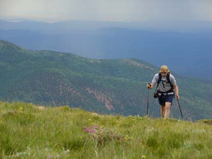 Bill starting up the east ridge of Mt. Maxwell. Sure we looked nice and fresh now but... In the fall, the area is plastered with yellow-leaved aspen trees setting the stage for a great view of the Spanish Peaks. We hiked for about an hour and found ourselves about 250 feet below the summit when the a small but scary rain/lightning storm passed overhead. This was our biggest concern for the whole trip--the afternoon thunderstorms. We figured once we got through to about 6pm, we'd be clear of any more lightning for the rest of the trip. As Bill's head hair stood up on end, we dropped off the ridge to the south and found a couple of spots to "hide" from the lightning. 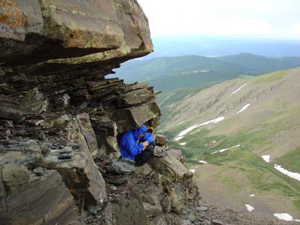 Our little shelters from the rain and lightning for about 35 minutes. This hiding did more for us mentally than really protecting us. We assumed our hiding positions for about 35 minutes and as quickly as the stormed arrived, it disappeared. There was plenty of action to our south and east still though so we started back up skeptically. The weather held and we reached the summit of Mt. Maxwell at 2:44pm. We signed the register that was placed by the "Republic of Texas Mountaineers" some years ago, looked long and hard at our goal and set off about 10 minutes later. 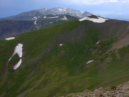 From the summit of Mt. Maxwell we could barely see Culebra and Red Mountain on the horizon a mere 12 miles to the south. Culebra is the peak in center sun with the most snow. Red Mt. is the summit left of Culebra with a small snow patch on it. Let the ridge hiking begin! From Mt. Maxwell the hiking was mostly class 1 or class 2 along the ridge with some class 3 hiking near Miranda Peak. This hike is a long slog and I won't bore you with the details of the ridge hiking. Don't get me wrong, the hiking is enjoyable and the surrounding scenery is amazing--we saw literally hundreds of Elk and Bighorn Sheep during our 21 hour hike--but covering this distance and vertical gain in 21 hours was tough. So here I offer the times of when we reached each summit along the way. We reached the summit and signed the register of our next peak, Manquita Peak (13,405'), at 3:23pm. From there we dropped quite a bit and reached the summit of DeAnza Peak (13,333'), at 4:10pm. After a short break we descended to one of the lowest points along the route, Whiskey Pass (12,500'). We then climbed back up to the summit of Beaubien Peak (13,182') at 5:25pm. Tangent: On Beaubien, I broke one of my long-standing rules and turned on my cell phone to call Allison and my parents. I did this for one major reason and one minor reason. The big reason was that I had spent 9 hours in the hospital the previous day with a "distended appendix" and almost went into surgery to have my appendix removed. However, the surgeon didn't deem surgery necessary so I went home to rest and see how it went. As I was released, I asked the doctor, "Are there any major restrictions or should I just take it easy until I feel better?" His response: "Son, if you feel better by tomorrow, you can do whatever you want." Those were the words I really wanted to hear as I was very excited for ODS III and didn't want to miss it. So...I called home to let Allison and my parents know I was doing just fine and to reassure them that if I felt poor, I'd turn around. The small reason for calling was that Allison and I had made an offer on a new house and I wanted to find out if the offer was accepted. They counter-offered and we didn't get the house but that's another boring story for another day. Next we summitted Franciso Peak (13,136') at 6:12pm. 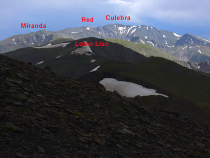 From near the summit of Francisco Peak looking south towards our objective. From there it was a nice jaunt across a large open grassy slope to the broad, flat summit of Lomo Liso Mountain (13,128'). We signed the register in a jar on this peak. It seemed a popular year on these peaks compared to the rest of the register's entries. At least 5 other people had signed the register on these peaks in 2005 which surprised us. I think I heard there was an "opening" around the Fourth of July, 2005, but I know little about the details of this opening. After leaving the summit of Lomo Liso, a light rain began to fall along with some decent wind. We donned our rain jackets and stashed our hiking poles among the boulders in the grassy ridge heading towards Unnamed 13,247' and Miranda Peak (13,468') as the terrain up those peaks looked like it would involve some class 3 action and some loose rock. Poles would just be a hinderance. After some scrambling on loose rock we made it over Unnamed 13,247' and reached the summit of Miranda Peak at 8:00pm. The sun was setting behind the clouds of a large, immobile rain storm to the west and the resulting sunset was fantastic! 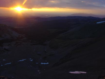 A beautiful sunset over the southern San Luis Valley seen from Miranda Peak. Sunsets like this make being miles away from your car on top of a peak well worth it! We watched and photographed the amazing sunset for about 10 minutes and then carried on as the light began to wane. We reached the summit of Unnamed 13,565' at 8:45pm and signed the register. It was now dark enough to turn on the headlamps. But before all the light dissipated we studied the rest of our route ahead. It looked to be mostly class 2 and continued to stay on the ridge. Our feet were starting to feel the effects of the distance but otherwise we both agreed we felt good. Carrying on we hiked over the summit of Unnamed 13,425' to the summit of Unnamed 13,701' at 9:41pm. We knew we were only a short distance from Culebra and were excited to be almost there. On our way down the ridge on the southwest side of U13,701', we spotted a good-sized pool of water that was obviously fed by a nearby patch of snow. We knew we'd need to stop on the return to fill up our bottles at this pool so we took a mental note. From the pool it was more class 2+ scrambling along the ridge towards the summit of Culebra. Around 10:15pm we paused to watch the orange-looking moon rise through the clouds on the horizon. Soon we'd have that special mental boost we were looking for--the bright light of the moon. At 10:30pm we reached the summit of Culebra and sat down for a much deserved break and sandwich consumption session. I thought back to my first time on the summit. It was in the wee hours of the morning surrounded by a heavy fog. I had no view. At least this time it may have been dark but it was clear, we could see the lights of Alamosa and the moonlight was slowing giving us more of a view of the surrounding landscape. It was totally awesome to be right there, right then with Bill on his third-to-last 14er summit. 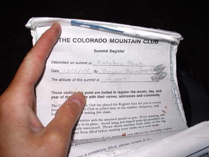 Signing the register on Culebra Peak. After our food and rest break, we stood up and decided to head to Red Mountain. We had previously discussed this option since we'd be "right there" and thought we'd make the decision once we reached Culebra Peak. I think we both knew we'd go to Red Mountain no matter what anyhow. The ridge between these two peaks is class 2 scrambling on large blocks down Culebra and involves some loose rock/dirt up Red Mountain. We did stumble upon a light trail up Red Mountain and reached its summit at 11:25pm. We signed the register and took some summit photos along with a few 30 sec. time exposure shots of Culebra Peak (the banner photo for this report!) It had taken us 10.5 hours to get here so we knew it would be at least that much time on the return. Time to buckle down and hit it. At 11:45pm we started back. Sunday, July 24th Midnight came while we were hiking back from Red Mountain towards Culebra. It was a beautiful night.On the return we opted to try and skirt as many summits as possible which really turned out to be only the summits of Culebra Peak, Beaubien Peak and Mount Maxwell. 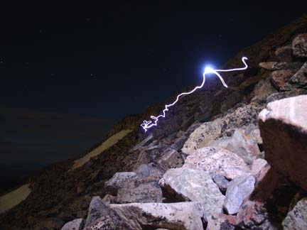 Bill's headlamp light shows our path while skirting the summit of Culebra on the peak's southeast side. At 12:45am we stopped to fill our water bottles at the small pond between Culebra and U13,701'. We each filled up at least two quarts of water for the rest of the hike. It promised to be a cool night so we didn't want to carry too much water. Hiking through the night was mentally tough as our bodies wanted to sleep but the light of the moonlight helped immensely. At times I felt very tired but minutes later I would feel nearly fully awake. At one point I was lagging behind Bill as we descended north from U13,247' and was nearly sleep walking when I heard Bill yelling and making growling noises. This noise caught my immediate attention and I asked Bill what was up. He asks, "Did you see that over there? It's an animal of some sort running at us. I can only see him when the light from our headlamps hits his eyes." I looked out and sure enough saw a pair of orange lights darting in our direction! We made some more growling noises and stood close to make us look bigger than we were. We both shined our headlamps on this creature and made it out to be a very curious fox! A few more times it would dart towards us and we'd make noises or throw rocks to scare it away. This incident, while a bit spooky, certainly woke me right up and had our adrenaline pumping for sure. We continued on both of us constantly scanning the ground about 30 feet away with our headlamps looking for the fox to come at us again. Without our hiking poles we felt un-armed and couldn't wait to get back to our poles in about 15 minutes. We never did the fox again the rest of the night. Near Lomo Liso again we picked up our hiking poles and I put on the rest of my clothes as the constant breeze was very chilly. More unrelenting plodding continued through the darkness until we neared the summit of Beaubien Peak around sunrise. The light of the sun was another big mental pick-me-up and we felt slighty rejuvinated by this view. 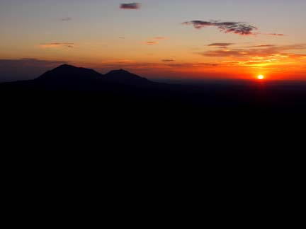 The wonderful glow of sunrise and the Spanish Peaks. I believe Bill took a growler around this time and we descended to Whiskey Pass before working hard to again cross over the summits of DeAnza Peak, U12,925' and Mariquita Peak. At the summit of Mariquita Peak we could see the rest of our route back to the car. We were pooped and moving very slowly by this time but were almost there. We dropped down to the saddle between Mariquita and Maxwell and skirted Maxwell's southeast face on loose scree. It wasn't fun but we didn't really feel like going up and over Maxwell's summit again! Picking our way down the east ridge of Maxwell we arrived back at the Jeep at 10:08am for a total of 21 hours hiking. It felt great to change back into sandals! We drove back down the road a bit to pitch the tent and sleep for a couple hours before driving back to Los Alamos that evening. Whew! Written by Jason Halladay on 05 August 2005. |