 Arrow Peak (13,803'), Vestal Peak (13,864'), Trinity Peaks Traverse (13,765'/13,805'/13,745')
Saturday, June 25th Aron and I awoke at our campsite near Little Molas Lake at 3:30am. After eating a bagel with cream cheese we loaded up into his truck to drive down to the Molas Pass trailhead just as a small, short hailstorm rolled through. This storm was just a preview of the hail squals that would continue throughout the next 20 hours. After sitting out the short hail squall in the truck, we left the Molas trailhead at 5am in a slight drizzle. 30 minutes into the hike I decided to pull out my rain jacket that happened to be at the very bottom of the pack (I didn't think I'd actually need it!) While zipping my pack back up, the zipper derailed from the teeth, breaking a zipper tooth. With no way to make the repair, I did some creative packing and strapping and was back on the trail in short order listening carefully for items falling out of the pack. The descent of 1,680 feet down to the Animas River went smooth and we arrived at the foot bridge across the river at 6:03am, mostly on schedule. We crossed the river and found the well-marked Elk Creek trail junction. Hiking up Lower Elk Creek was smooth on a well-defined and maintained trail to the large beaver pond at 9,980' feet. We paused momentarily to take photos of Arrow Peak and Vestal Peak reflecting in the beaver pond before heading south and down to the Elk Creek Crossing. Elk Creek was flowing huge and we were unable to find any "nice" way to cross the creek. The only option we found was a bare, wet log of about 10 inches diameter going most of the way across the creek. We gave up our pride and dry socks and straddled the log to scoot across. As our legs dangled in the water, the creek's power almost swept us both off the log making for some scary moments. 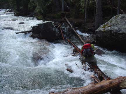
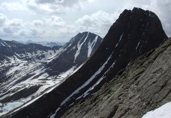
Aron humps his way across the raging Elk Creek. After crossing the creek we headed straight uphill to find the faint but very helpful trail up into the basin. Search hard for this trail after the creek crossing as it makes the ascent much more proficient. At 9:00am we reached the base of Arrow Peak's Northeast face route as the morning clouds finally burned off. The route looked great! A nice snow route on the east side of the major rib between the east and west ramps was in. After ascending the grassy ledges along the lower section of the huge ramp, we strapped our crampons on to our trail running shoes and began the ascent up the snow. Aron soon crossed onto the rock rib but I was enjoying the snow climbing and kept going until my feet were completely soaked. At that point I too moved onto the rock rib leaving my crampons there and scrambled up decent class 3 terrain to the summit. We reached the summit at 10:20am as the sky began to cloud up again. I wringed out my socks and we began the descent of our ascent route. We came across a small tree growing at close to 13,750' just below Arrow's summit. Aron proclaimed it the highest tree in all of Colorado but can't be entirely sure of that statement. In any case, it was a unique sighting. As we descended the route I kept looking hard at Wham Ridge on Vestal Peak and was seriously considering soloing that route as Aron ascended the loose scree of the "Dues Collector" slope to the South Face route of Vestal. Thankfully (for my mother) the second hail squall of the day came rumbling through as we reached the base of Arrow Peak squelching any ideas I had of soloing the route. Instead we got to kick steps up decent snow up the "Dues Collector" slope to the Arrow/Vestal saddle making the slope seem quite cheap. From the Arrow/Vestal saddle at 12:15pm we traversed and then ascended the good class 2+ rock of Vestal's South Face route to the summit of Vestal Peak at 12:55pm. From the summit we had a great view of our intended route to of the Trinity Traverse, Storm King, Silex and The Guardian. Looking at the distance to The Guardian, I swallowed hard trying to fathom the undertaking we were attempting--it looked so far! 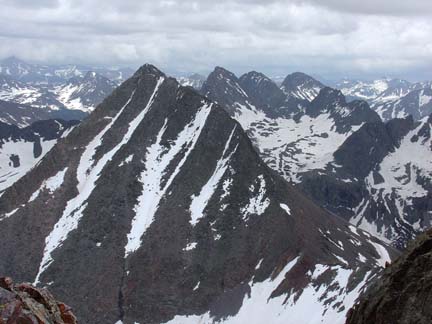
The view east from the summit of Vestal Peak. You can see the summit of West Trinity in the foreground with the summit of Trinity Peak jutting above West Trinity's summit. From there the next major peak is Storm King followed by Mount Silex and The Guardian. The clouds were beginning to roll in again so we began our descent to embark on the classic Trinity Traverse of West, Middle and East Trinity Peaks. We were noticing a nice pattern in the weather--after each summit, we encountered a brief hail storm. Some thunder did accompany these storms but we never saw any lightning ground strikes so we crossed our fingers for continued good luck. At 1:20pm we began the short traverse/hike to the Vestal/Trinity saddle. Getting the the V/T saddle involved crossing one small snow couloir and hiking a snowy ridge. 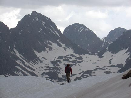
Aron hiking the snow ridge to the Vestal/Trinity saddle. Storm King, Mount Silex and The Guardian dominate the skyline. Once we reached the V/T saddle we re-read Ryan Schilling's excellent route description of the Trinity Traverse and embarked upon the traverse. The scrambling up West Trinity was straight forward but the freshly watered rocks forced us to pay close attention to every foot placement. While we ascended the weather again cleared and we enjoyed great views to the south. 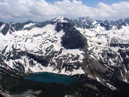
Looking south towards the Needles with Balsam Lake in the Tenmile Creek drainage in the foreground. At 2:45pm we reached the summit of West Trinity Peak. Again, the dark storm clouds were building to the west so it was time to carry on. We took a good look at Trinity Peak and began descending the class 2+ rock down to the West Trinity/Trinity saddle. Near the saddle we found a decent stream of water flowing from a small snow patch that allowed us to refill our water bladders. From the saddle we followed the well-cairned ledge east and up to class 4 crux chimney. The moves in the chimney weren't difficult but again, the wet rock made us think twice before making any committing moves. 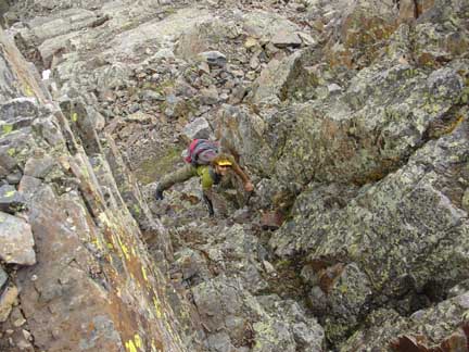
Aron ascending the 4th class chimney on Trinity Peak. From the top of the chimney we turned right following a good ledge. This turned out a mistake as the ledge petered out and forced us to retreat back to the top of the chimney. We then saw the cairns above the chimney and scrambled up to the small "basin" below the summit of Trinity Peak. From there, wet but enjoyable third class rock took us to the summit at 4:15pm. This time the clouds were rolling in darker and more ominous than the rest of the day. We could see major cells of rain to our north, east and west. Our time on the summit of the highest of the Trinities was cut short due to this sight and we started down the loose, semi-nasty east couloir of Trinity Peak to the Trinity/East Trinity saddle. As we reached this saddle, the weather hit us hard. 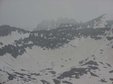
Looking at Jagged Mountain as nasty weather rolls in on us between Trinity Peak and East Trinity Peak. Heavy hail mixed with rain and a good dose of rolling thunder forced us to sit a while at the Trinity/East Trinity saddle. This weather, however uncomfortable, was well-timed as it helped us make the decision to end the day's climbing with the summit of East Trinity. If we continued with our planned route, once we left East Trinity we be farily committed to a super long outing going for Storm King, Silex and The Guardian. The day's weather had slowed us down much more than we had planned and it was now nearly 5pm and we still had a long way to go to tackle the the remaining three peaks of our plan. Best not to tempt the weather gods and make a hasty retreat to the comfort of our sleeping bags. The decision was easy. Once the hail and rain stopped, we ascended the now very wet rock of East Trinity's west couloir taking good care and reaching the summit of East Trinity at 5:51pm. The clouds had again temporarily cleared making us second guess our decision to head back to the truck but also giving us a great view of Windom and Sunlight to the south. 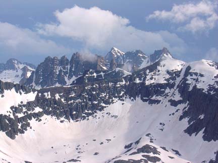
Looking south at Windom Peak in the sunlight. After snacking and reaffirming the plan to retreat, we started down East Trinity's east ridge as the clouds, rain and thunder started up again. Indeed a good decision. As we reached Vestal Basin the rain came in hard again--this time with some lightning ground strikes in the distance. This fact quickened our step to get us to treeline by 7:15pm. Walking through the rain-soaked willows was awesome and our shoes quickly became "water socks" for our feet. It was sweet. By 9:20pm we reached the crossing of Elk Creek and thoroughly enjoyed the wet, scary log crossing back across the creek. By this time the hike had turned into a wet, miserable slog. We stopped by the beaver pond to wring our socks out again which proved totally futile as we hiked not more than 10 minutes before wet plants along the trail soaked our feet again. Oh well, nothing to do now than just keep hiking. We reached the Animas River footbridge around 11:00pm. Time to suck it up and ascend the 1,680' feet up to the truck. Again, the rain rolled in making for a soggy ascent to Molas. The ascent seemed to take four hours instead of two but finally at 1:03am, after 20 hours of hiking, we arrived at the Molas trailhead. Soaked and exhausted we changed into dry clothes and jumped into the sleeping bags. Written by Jason Halladay on 26 June 2005.
|