 Jopuno (5,936m), West Ridge
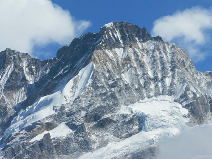
Since I first got a sight of the ridge during our approach eleven days earlier up the Thangsing Valley I had been focused on it. The unclimbed west ridge of Jopuno (5,936m) looked amazing and right up our alley. Not too difficult but definitely not a gimme either--a short rock ridge to gain the glaciated lower ridge which quickly turned into a steep, sharp snow ridge leading up to some gorgeous golden granite. Above the golden granite the rock appeared black and loose which was sure to be exciting and less than pleasurable. And then there was the snow-capped summit nearly 6,000 meters above sea level. It was a very aesthetic peak and route and I anxiously looked forward the first ascent attempt of the ridge. As best we could surmise, Jopuno had been climbed only once previously via the south ridge in April 2002 by Kunzang Bhutia and Sagar Rai. Our group of four climbers (myself, Sarah DeMay, Sam Gardner and Josh Smith), a liaison officer (Suraj), a local guide (Dawa), a cook (Bomba) and his assistant (Arjun), and numerous porters had began our expedition into the Himalayan Mountains surrounding the Thangsing Valley in West Sikkim, India on March 7th, 2008 and spent four days trekking along the popular Gocha La trekking route from Yuksom to our base camp at 4,200m on a grassy shelf on the east side of the Thangsing Valley directly below the west ridge of Jopuno. From our base camp we had a tremendous view of Kangchenjunga (8,586m), the third highest peak in the world, at the head of the valley. From here our guide and liaison officer would no longer be accompanying us up the mountain but would stay at base camp while we moved up higher on the peaks. Once established at our base camp, our first week’s objective was a climb of the Northwest ridge of Tinchenkang (6,010m) which has been climbed only a few times. After establishing a high camp below the Northwest ridge of Tinchenkang at about 4900m and resting a couple of days up there we had made an attempt on the peak but got turned around at about 5,500m on the glaciated ridge due to snow and white-out conditions. We had run out of food supplies at our high camp so we packed up camp and returned to base camp on March 17th with our next objective, Jopuno, in mind. After a rest day at base camp and a reconnaissance day up to the base of the glacier on Jopuno’s west ridge, all four of us left base camp at 3:30am under the light of the nearly-full moon to make an attempt of Jopuno’s west ridge. The going was fast and straight forward on grass and talus to the base of west ridge about 16,900’. 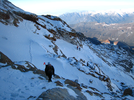 Gaining the ridge and glacier at about 16,900’.At that point we donned crampons and began wanding our way up the lower glacier to the first major obstacle on the route, a short, 40 foot WI3 pitch to gain the upper glacier. Josh led the pitch placing only a couple ice screws and I followed. Sam and Sarah followed us with Sam in the lead on their rope. 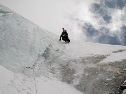 Josh leading through the short water ice pitch to gain the upper glacier.After the short water ice pitch, we enjoyed a few hundred feet of great, steep snow climbing on the face of the glacier as it continued to narrow into the well-defined icy and exposed ridge below the golden granite band of rock above. 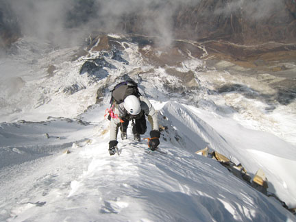 Up high on the well-defined snow ridge.About 100 feet below the start of the golden granite band the ridge turned into solid water ice and traversed slightly to the right above a very exposed face of ice. We again roped up here so Josh could be belayed as he climbed up and placed a few ice screws to gain the golden granite at about 18,500’. I followed up and joined Josh at the golden granite around 10:30am where we again unroped for the scrambling above. Sam and Sarah were a few hundred feet below us at this point but were still moving up. The climbing through the golden granite was more challenging than it had appeared from below but at least the rock was solid. We slowly picked our way through the golden granite following the path of least resistance only reversing our steps a few times when had become stymied by steep or otherwise impassable rock. For the most part we stayed below and to the right (south) of the ridge crest proper. 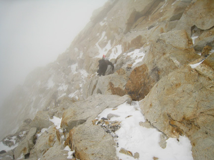 Working our way through the nice golden granite band.After climbing through the pleasant golden granite we encountered the rotten and very unpleasant black shale rock section at approximately 19,000’ around 11:30am. Also, by this time the wind had picked up and it had begun to snow lightly. We radioed to Sam and Sarah and they informed us they had just reached the golden granite band but were going to sit and wait for us to return because the weather was worsening. We told them we expected it to take another hour or so for us to reach the summit and descend to their position. We continued up very cautiously and tediously through the black shale which was quite a treacherous thing to do given the poor rock quality and lack of any previous traffic. It was not uncommon for chunks of rock to slough off underneath the weight of our hands and feet. Upward progress became a slow process as we tested and retested each hold before committing our full weight to it. To add to the treachery, the new snow on top of the shale made the surface slick. We kept our crampons on the entire time as the metal points offered much better traction than our boot soles alone would. 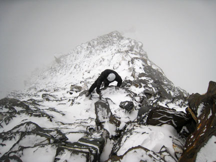 Tedious work through the nasty black rock not far from the summit.Then, with no warning, both Josh and I began to feel the sensation of hundreds of bees stinging us around our faces, shoulders and legs. A huge amount of electricity buildup in the air was causing the metal of our glasses, wands, ice screws and ice tools to sting us through our clothes. We immediately jettisoned all of our metal accoutrements on the ridge proper and descended a few feet below the ridge crest to decide our next course of action. As we were discussing a disappointing descent from only 200 feet below the summit, the electricity in the air dissipated and we gathered our metal equipment and continued up again. For the final 200 feet we were on the ridge crest and passed back onto some solid snow and ice for the last bit of climbing to the summit. We reached the summit around 12:45pm in near white-out conditions with a view of about 30 feet in any direction. Since it had taken significantly longer to reach the summit than we had expected and we knew Sam and Sarah were still waiting for us, we only spent a few minutes on the summit and began our descent. Descending the poor, loose, snow-covered black shale was more tedious than our ascent of the same rock. 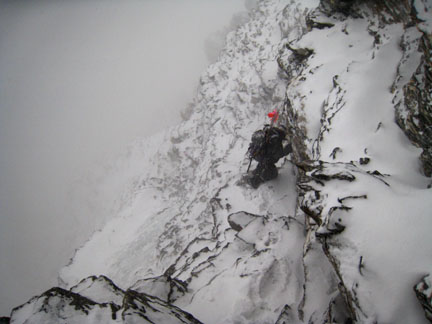 Descending the exposed, black rock band wasn’t exactly awesome.I often found myself using my knee and my ass to aid in my down-climbing maneuvers when I would normally consider that poor style. It was quite a relief to reach the solid rock of the golden granite and even more of a relief to meet up with Sam and Sarah again around 2:15pm. By the time we had reached Sam and Sarah the storm’s winds had intensified and we were all getting very chilled. Any exposed flesh on our face got stung by the blowing snow and wind and I had a hard time imagining how cold Sam and Sarah must have been having sat still for a couple hours on a very exposed section of the ridge waiting for us. I really appreciated their company even more after pondering this fact. Sam and Sarah had rigged up a rappel anchor from the bottom of the golden granite band so we could rappel the off-camber icy ridge section. We all took turns rappelling and we continued the process of rappelling 30m at a time along the ridge leaving ice pickets as anchors when necessary. 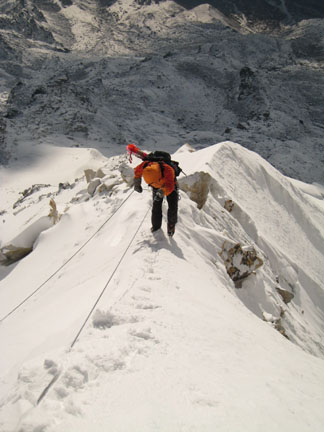 Sam rappels during a welcomed break in the storm.As we got lower, three of us rappel and then either Josh or I would break down the anchor and down climb because the angle was lessening and the snow improving. The sun came out briefly giving a great view of the peak and surrounding valley covered in new snow but then the wind and blowing snow returned chilling is even more. As we neared the bottom of the glacier darkness came. We broke out our headlamps and rigged the final rappel down the water ice pitch we climbed to initially gain the glacier. We got off the glacier around 8:00pm. Looking down the valley toward our camp we could see the blinking head lamps from Suraj and Dawa back at camp. When we finally got back into camp around 10:30pm Bomba had prepared a large, hot dinner for us and we were stoked! Over dinner we told Suraj and Dawa the details of our climb and they were genuinely happy for our success. We rolled into our cozy sleeping bags at 11:30pm for it had been a long day. All told we had climbed 5,860 vertical feet all above 13,800’ in a long 18.5 hour day in some trying weather conditions on an adventurous outing during a first ascent. I fell asleep feeling greatly alive. 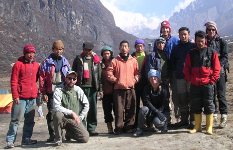 Our great expedition group at the end of the trip.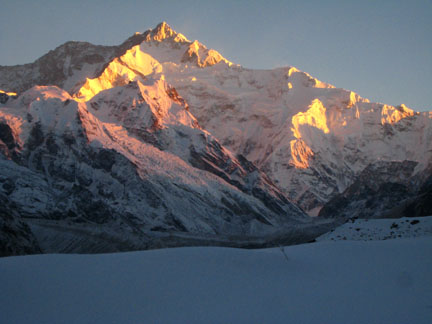 A parting shot of Kangchenjunga at sunrise from our base camp.If you're interested in more information about mountaineering in Sikkim and some more history of mountaineering in the region, the 2008 American Alpine Journal that was just released has a very good write-up by British mountaineer and guide Roger Payne. His story, Emerging From The Mist, The sublime alpine peaks of Sikkim, India, starts on page 112. Written by Jason Halladay on 07 October 2008 for TheMountainInstitute.com.
|