 Montana's Highest Mountain-Granite Peak, Montana (12,799')
Friday, July 1st Erik and I left Los Alamos a little after 5pm headed north. We had to pick Bill up at DIA on Saturday around noon so we took our time getting up to Colorado. On the drive up Erik suggested a night climb of a peak to kill time. I was just getting over a stomach flu but the idea sounded interesting. Which one? Well, there's decent camping near Kite Lake and neither of us had climb Mount Buckskin. Deal. At 10:30pm we set off in the dark up the slopes from the Buckskin Gulch TH. A clear, mostly calm night was the order for the evening. We summitted Mount Buckskin a little after midnight, descended to Kite Lake and walked the road back to the car lower down at the Buckskin Gulch TH by 1:30am. A nice three hour tour. We sacked out under the stars by the road. Saturday, July 2nd After waking up around 6:30am we stopped in Breckenridge for coffee and bagel sandwiches and cruised into Denver and way the hell out to DIA by 11:30am. We had Bill in tow by 12:15pm and hit the road north driving through Cheyenne, WY and Casper, WY. Dinner at the Wonder Bar grill in Casper was filthy good. However, my stomach wasn't yet normal and, in extremely rare form, I did not finish my meal nor my 24oz New Belgium 1554 Black Ale. Not to worry, Erik took it for the team and cleaned up after me. Well done, E! On the road for a few more hours found us driving through Shoshoni, WY and Thermopolis, WY. We stopped to check out the "largest mineral hot springs in the world" in Thermopolis at sunset. Sunset sounds late but at that northerly location, it was really like 9pm. We hit the road again plowing through Red Lodge, MT and finally finding some national forest land near Luther, MT after midnight. Accessing national forest land in MT is difficult as it turns out. We had to go about 13 miles off the highway to get to NF land. But we made it and slept like babies in the tent that night. Sunday, July 3rd We slept until nearly 9am. Packed up and on the road again we finished the drive to the Mystic Lake trailhead in the Beartooth Mountains in the Absaroka Wilderness. The driving that morning was beautiful and very idlyllic. Wonderful Montana country. We packed up our overnight bivy backpacks and set off up the trail at 11:55am for three miles to Mystic Lake. Mystic Lake has a hydroelectric plant attached to it so we had a great view of a gigantic water main from the trailhead all the way to the lake on the opposite side of the valley. We passed a number of day hikers on the way to the lake and at 1:08pm we were rewarded with a fantastic view of the gigantic Mystic Lake. 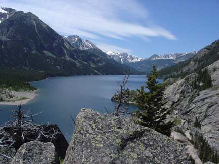
Mystic Lake view. The lake consumes nearly 3 miles of land in the valley. Awesome. We could also finally see some higher peaks in the background towards Granite Peak. We found a nice section of beach along the lake and enjoyed an afternoon snack by the water before heading on. We had to make a decision about our route at this point. There are two ways to approach the east ridge of Granite Peak--via Froze-to-Death Plateau or via Huckleberry Creek. We didn't like the sound of "too numerous to count" switchbacks up to Froze-to-Death Plateau so we decided on the "log and boulder hopping" up Huckleberry Creek. Huckleberry Creek reaches Mystic Lake on the the lake's west side so we hiked along great trail past numerous campsites and fishermen to the far end of Mystic Lake. At the point where a large stream with a nice wooden bridge over it enters the lake from the south, that's Huckleberry Creek. The description we had wasn't too obvious about this so we spent a little extra time hiking more to the west and ended up Island Lake before realizing we had passed Huckleberry. Backtracking we found a small cairn marking a faint trail up the creek's west side. We took this trail and it quickly turned into a nice trail. Around 3:30pm we began the boulder hopping in earnest and hopped past Huckleberry Lake around 3:45pm. From there the trail was faint an intermittent between short sections of boulders and vegetation but with decent route finding skills it's not hard to stay on track. The trail steepened considerably to climb up to Princess Lake at 9,170' at 4:45pm. 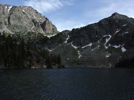
Princess Lake view. We considered camping here but the mosquitos were quite annoying and we were eager to get up a bit higher so we passed Princess Lake on it's east side involving some bushwacking and steep talus hiking. As we hiked higher I was getting worried we wouldn't find a flat spot to bivy for the night but Bill and Erik spotted a great spot just above Cold Lake in the Boulder Field amongst some large boulders. We were so pleased with this spot and the view of Granite Peak it offered that we plopped our packs down and set out our sleeping bags and bivy sacks for the evening at 6:45pm. 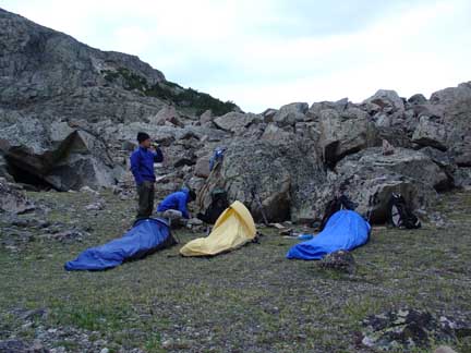
Our wonderfully cozy bivy site just below Avalanche Lake. The dark clouds were threatening and spit some graupel every now and then but never got serious. Erik busted out the evening's surprise--an authentic government-issue MRE (Meal Ready to Eat). It turned out to be a ham and shrimp jambalaya thing and I don't do seafood so I didn't get into the main dish but the jalapeno cheddar cheese spread on wheat bread cracker was quite tasty. We also all shared the one Sierra Nevada Pale Ale beer that Erik had hauled up as we ate our other freeze-dried meals. Around 9pm we all crawled into our bags for the night happily full of food. Monday, July 4th (Independence Day!) The watch alarms sounded at 4:45am and we were up. Erik also managed to carry up a backpacking espresso maker so he and I each had a couple shots of espresso to get the engines running (Bill doesn't drink coffee.) By 5:45am we were happily boulder hopping on gigantic boulders to Avalanche Lake at 9,870', passing the lake on it's east side. We also noticed what would be a fantastic camp site at the southeast end of Avalanche Lake on our ascent. At the south end of Avalanche Lake we stepped onto snow for the first time this trip and followed a good set of previous boot track in the snow up to the saddle between Granite Peak and Tempest Mountain at 11,450' at 7:55am. 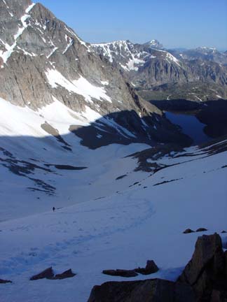
Looking down towards Erik and Avalanche Lake from the Granite-Tempest Saddle. Erik and I carried crampons and I was the only one to bust them out as I was sporting Salomon Gore-Tex trail runner shoes for footwear. The extra security of the crampons was nice but not a necessity as neither Bill nor Erik had any issues just using the old boot track in the snow. Bill was wearing light hiker shoes while Erik went full-on with his leather mountaineering boots. A decision he'd later regret due to severe heel blisters resulting from the boots. From this saddle we had a great view the East Ridge route to Granite's summit. We were in for quite a bit of snow but that was just dandy with us. We cached our overnight stuff here at the saddle as we'd return this way on the descent. 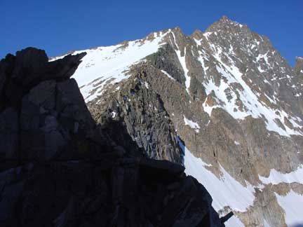
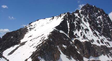
Looking at the East Ridge of Granite from the Granite-Tempest saddle. We also noticed a couple ahead of us chopping steps in the snow along the east ridge. We commented on how they should just wait a few minutes for the sun to do its just on that southeast-facing snow but perhaps they were in a hurry? Nonetheless, their chopped steps made for easy going on our part and we quickly met up with them. Turned out they were from Boulder, CO. We chatted briefly and took our turn making the steps. By that time though, the snow was soft and we had an easy time making the steps. We made good steps up the snow staying just south of the east ridge proper and arrived at the top of the first ridge section at 9:05am to a great view of the infamous "snow bridge" feature. This is a short, maybe 100 feet, section of snow ridge that is often protected with a rope and pro. 
The snow ridge around 11,650'. Previous steps in the snow were quite nice but we still let Erik, with his heavier mountaineering boots, go first to kick the steps in even better. A slip crossing this section would send one sliding down 800' feet of steep snow to the south. One step at a time and with ice ax in hand we passed this section to find our first fourth-class chimney of the day on the other side. Deciding we'd not need the ice axes anymore, we cached them just beyond the snow ridge section. We worked our way up the good rock of the first fourth-class chimney without difficulty only to find more snow on the next section. Damn, should have brought the axes with us. Oh well. We each found a "poor man's ice ax" (a sharp rock in hand) and passed the next section of snow to the next fourth class chimney climb. 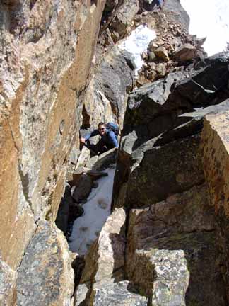
Erik making his way up the second 4th class chimney. At the upper end of this next chimney was yet another section of snow that would be nice to cross with an ice axe. Damn. Another rock in hand and careful steps got us past and into the next fourth class chimney. We were noticing a pattern here. Yep, sure enough, more snow to cross after this third chimney. After crossing this last section of snow we were at the final summit pitch section. To this point cairns and obvious traffic lines had helped us navigate but we also had been referencing a photocopied detailed and accurate route description we found on the internet that came in very handy. 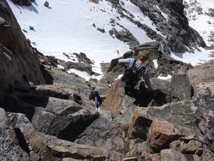
Climbing the most difficult portion of the route. Erik and I both agreed that two moves in this final chimney were low fifth-class moves. This route description jived with what we were seeing and we found a great route up to the summit. We arrived on top of Montana at 10:30am and soaked in the view of the surrounding peaks of the Beartooth Mountains. Wonderful views to the south showcasing snowy north facing aspects. 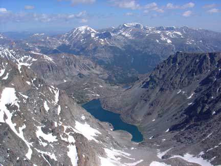
From the summit looking down into Huckleberry Creek drainage at Avalanche Lake. I thought about how cool it is to be on top of a peak in a "new" mountain range and not know the names of surrounding peaks. I spend so much time in NM and CO that I can name many neighboring peaks from the summit of most peaks. Here in Montana, I had no idea! As we snacked on top we heard a commotion to the south. Looking over across the valley we watched a wet slab avalanche rip down an easterly facing slope. Wow! We didn't find the famed brass summit register but did notice two old bolt holes in the summit block and assumed that was the old brass register's home until someone or soemthing ripped it off. The air was still and the day perfect so we lounged on the summit for nearly 30 minutes. But we were all thinking about the downclimbing on the descent and were eaget to get it overwith. A little after 11am we started down and began reversing our 4+ class moves. To our surprise the moves weren't that difficult. We passed numerous rappel stations and talked about how much more efficient our downclimbing was compared to the time it would take to rappel all these sections. We were glad we opted to leave the rope in the vehicle. By 12:30pm we were back at the Granite-Tempest saddle after some boot glissading down the east ridge. We discovered that despite our best efforts to "marmot proof" our bags and poles, a couple of marmots got to chewing on my pole handles a bit. Oh well. We shouldered our packs and began the ascending traverse along Tempest Mountain's northwest face to Froze-to-Death plateau. Erik counted exactly 700 steps along this traverse. I can't count that high so I didn't count. Hiking along Froze-to-Death plateau offered a great view of the surrounding peaks and other high plateaus all around. 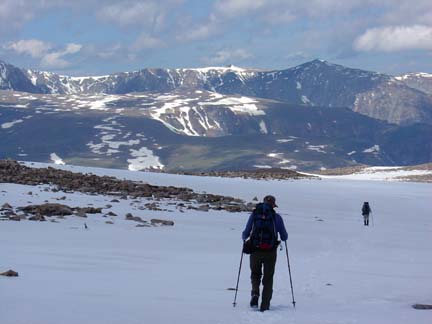
Descending via Froze-to-Death plateau. We passed approximately 8 good rock-walled campsites along the plateau and there was certainly plenty of water flowing in various locations that would make for good camping up there. The plateau dragged on for a very long time and finally, at 3:40pm, we reached the Phantom Creek trail of switchbacks leading back down to Mystic Lake. This trail is in great shape and consists of 29 switchbacks. We commented on how glad we were not to have ascended this route but descending it made for a bountiful Tour de Granite. By 5:00pm we were back down to Mystic Lake and an hour later we had arrived back at the vehicle for what amounted to a little more than a 12 hour day. After a bit of stream bathing and sucking down a beer each we hit the road en route for our next adventure--a day hike of Idaho's highest mountain, Borah Peak (12,662'). Written by Jason Halladay on 11 July 2005.
|