 Aoraki (Mount Cook), 12,316', New Zealand (Attempt)
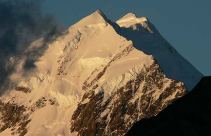
Introduction At 3,754 meters (12,316'), Aoraki-Mount Cook is the highest peak in New Zealand's Southern Alps. The peak is also very aesthetically appealing surrounded by major glaciers and rocky peaks. For many years of my late youth I had dreamt about a trip to New Zealand after my great Grandmother had travelled there in 1986. Once I began climbing mountains I discovered Mount Cook and that seemed like the obvious objective during a trip to New Zealand. In early 2005, Allison and I began discussing a trip to New Zealand and Australia and naturally I used my charm and influence to attempt to talk her into Mount Cook. She was quick to poo-poo the idea of her climbing the peak but we decided Bill would likely be interested in it and indeed he was! We later mentioned the idea to our good climbing partner and friend Chris and soon he had purchased his airfare as well. Next was route discussion and one route stuck out as being totally awesome--the Grand Traverse (GT) of the three major summits of Mount Cook, Low Peak, Middle Peak and High Peak. The GT is normally done with an approach on the lesser used Hooker Glacier on the west side of Mount Cook with an up-and-over descent down the normal route of the Linda and Tasman Glaciers. For us the GT would be a great test and challenge and one we looked forward to. However, as the summer in the Northern Hemisphere progressed, the winter in New Zealand was very dismal leaving the glaciers high and dry and promising sketchy conditions. But we were committed with our non-refundable airfare and were determined to give 'er a go. Monday, December 19th After nearly 20 hours of flying from Albuquerque to Los Angeles to Sydney, AUS to Christchurch, NZ, we arrived in New Zealand around 4pm. The long flights were surprisingly easy we thought. Unfortunately, as we experienced last Christmas in Argentina en route to Aconcagua, our luggage did not arrive with us. We were told we'd be contacted as soon as it came in and that there were more flights that night from Sydney that would probably bring our luggage. We had previously arranged a rental car (subaru wagon) and lodging at a local hostel in nearby Sumner so we retreated to our rooms that night after some dinner. Our spirits were high that the luggage would arrive promptly. Tuesday, December 20th I awoke at 7am and immediately starting calling to see if our luggage had arrived. It had not but more flights were coming in that day. Still optimistic we headed out to explore the nice city of Christchurch and some of the local beaches. The weather was slightly overcast but the temperature was in the upper 60s and very pleasant. The day of city sight seeing was nice but we were getting anxious to start the climb. At 4pm we drove to the airport determined that the luggage would arrive. Low and behold it came in on the same flight we had arrived on a day earlier! Wasting no time we crammed our seven duffel bags of stuff into the car and headed south towards the Mount Cook Village--a four hour drive. Driving on the "wrong side of the road" was a bit odd and nerve-wrecking at first but didn't take too long to get used to other than the turn signal lever being on the opposite side. That resulted in a lot of unnecessary windshield wiper action but just a nuisance at worst. After a couple of hours we were ready to find a place to sleep and ended up renting a small cabin at an RV Holiday Park in Fairlie, NZ. Wednesday, December 21st We finished the drive to the Mount Cook Village by 9:30am and checked in at the ranger station to check on weather and conditions as well as the hut availability. The Mount Cook area has numerous backcountry huts that offer sleeping pads, cooking utensils and solar powered lighting as well as a restroom. These huts are all first-come, first-served and generaly cost between $20 and $30 NZD per night per person. We figured that was a reasonable price to pay considering there are no fees associated with entering the park or climbing the peak. Also, the weather tends to be poor on Mount Cook and spending days in the tent isn't a great prospect. We weren't surprised when we heard conditions were fairly difficult and dicey and that the huts were pretty much wide open due to a lack of climbers. There hadn't been any overnight freezing below 3000m for the past week and it had been raining most of that time. Conditions sounded less than ideal but we had travelled so far it was time to find out for ourselves. We signed in and gave our approximate itinerary before leaving the ranger station. Everyone was very laid back and were very non-chalant about us heading up and about our itinerary. I liked the relaxed attitude compared to the often overly cautious attitude found in National Parks of the United States.
We drove to a public shelter in the village to pack up our packs and ready them for the climb. At 12:30pm Allison dropped us off at the Hooker Glacier Valley trailhead with plans to see us again on Christmas or the day after. In the meantime she would enjoy some sightseeing on the eastern coast of the South Island and a trans-island train ride from Christchurch. We said our goodbyes and hit the trail under cloudy, gloomy conditions.
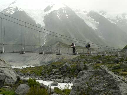 Crossing the Hooker River via one of the two suspension bridges that span the river. We didn't cross the second one as the trail that stays on the east side of the Hooker Valley starts right before the second bridge.There are two ways ascend up the valley--the west side right along the edge of the Hooker Lake and the east side on a bench above the Hooker Lake. Given the wet and rainy conditions and potential of loose rock falling down into the lake on the west side we chose the safer but slower route on the eastern side of the lake and valley. This trail was good for a while before braiding a bit and leading us astray. We ended up staying too high and doing a lot of bushwacking which made things very slow going. We would find out on the descent that there's an awesome trail down below where we hiked on the way up. It seems that's often the case--finding the good trail is much easier once descending. It ended up taking us 3.5 hours to walk to the upper end of the Hooker Lake. Terrible time.  Where the Hooker Glacier meets the Hooker Lake. Really wet ice!During this time it sprinkled rain off and on but every once in a while the clouds would break giving us a decent view of most of Mount Cook. As we caught a good glimpse of it I swallowed hard scanning the very intimidating looking ice and glaciers jutting down the west side of the peak. I was contemplating the idea of turning around at the sight of this. The glaciers looked so gnarly and spooky and were certainly more serious than any of the glaciers I've yet to experience. But we moved on slow and steady descending a major gully at the northern end of the lake and down onto the rock and ice moraine of the Hooker Glacier. From here the view up glacier certainly looked dicey and we could see we would have some major icefall negotiating further up the glacier.  Looking up the lower portion of the Hooker Glacier. The major rock lump just right of center is called Pudding Rock. Our destination for the day, the Gardiner Hut, sits atop that rock. Cables bolted into the rock on the rock's south side assist climbers up the mostly 4th class but some lower-5th class climbing. However, just getting from the glacier to the rock was the big crux of this trip.The footing and moving along the moraine was slow and ardous with plenty of loose rocks on top of ice to keep us attentive. Small rises and descent in the moraine also kept us moving farily slow but finally, around 7:15pm, we reached the start of the actual snow and ice of the glacier and strapped on our crampons.
We were excited to make good time for a while on the lower glacier where the snow and ice was farily consistent and smooth but by 7:45pm we were entering the icefall area of the glacier and progress really slowed down here.
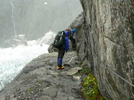
 Normally the glacier shouldn't be this nasty at the end of December but a very dry winter and unseasonably warm December temperatures made for tough going on the glacier. Note we did not rope up through this section of glacier as conditions were WYSIWYG (What you see is what you get) and there likely wouldn't be any hidden gotchas. With all the weaving we had to do, roping up would have been super slow and a hinderance.Working our way through the icefall was like entering a maze and we often found ourselves backtracking after coming upon an impasse in the ice. Initially we tried staying on the eastern edge of the glacier but found it to be very broken up there so we moved towards the center. It was painstakingly slow through this section and I think we were all beginning to second-guess this climb. It was frustrating we could clearly see Pudding Rock and the location of the hut but between us and the goal were tons of deep crevasses and holes that really challenged our routefinding skills. After moving towards the center of the glacier we came across a "trough-like feature" in the glacier that made for relatively good progress towards the bergschrund separating us from the rock. At the bergschrund it was looking fairly hopeless for finding a way across but I did some scouting and found an exposed but moderate downclimbing section that lead us to an old avalanche snow cone that allowed us to reach the rock. Once on the rock we were forced to do some 4th class scrambling in our crampons before reaching the bottom of the fixed cables on the rock. A kind of via ferrata. By this time it was 9:30pm and we only had, at best, 30 minutes of light remaining in the day. We quickly shed our crampons, put on our headlamps and clipped our cow-tails into the cables and began the ascent up. All the days rain had funnelled down this section of the rock and the cables only helped attract the running water so each time we placed a hand the cable water ran down our sleeves. Some of the moves were borderline fifth class in my opinion and I was glad to finally reach the top of the cables and Pudding Rock around 10:30pm.
Two other climbers from Australia were in the Gardiner Hut and had seen us coming up earlier in the evening. They had thoughtfully started a pot of water for us and the hot tea was a wonderful gift upon our arrival at the hut. We were all spent both mentally and physically by that time and enjoyed a quick freeze-dried dinner before going to bed.  Nearing the middle of the Hooker Glacier. We crossed from the east side to the west side of the glacier relatively quickly. Lots of stuff falling off from above the eastern edge of the glacier kept us attentive!Visibility and progress was good for a while and I felt a lot more comfortable on this portion of the glacier as it was considerably more smooth and easier to naviagate. However, as we go higher the clouds got thicker and it began to snow lightly. At one point where we were about to enter some gnarly looking stuff I lost the tracks we were following and things went into total whiteout. When we were about to start heading towards the middle of the glacier (which turned out to be the wrong way because of huge gapers) the clouds lifted momentarily giving us a good view up and we caught sight of the previous tracks and a good route through the gnarliness. Divine intervention! The clouds and snow kept on but if I really concentrated I could make out the previous tracks and we were able to finally catch a glimpse of the Empress Hut after negotiating some very deep crevasses on the upper Hooker Glacier. We reached the Empress Hut around 1pm in a serious fog. The Empress Hut is a very luxious and large hut that sleeps 12-14 and we had it to ourselves! We settled in and Bill fired up our stove to cook some pepperoni and cheese pita melts that really hit the spot! The reading material in the hut was very male-orientated and included issues of FHM, Stuff, Raplh and Australian Penthouse. These magazine kept us entertained the rest of the afternoon and evening until the 7pm radio call. Just as the radio call began, the sky began to clear and the views from the hut were stupendous! It was quite the treat having ascending in total whiteout not knowing what kind of terrain surrounded us. The steep and tough south face of Mount Hicks was practically on the deck's doorstep and the views down the Hooker Valley were amazing.
 Looking down at the upper Hooker Glacier from the Empress Hut. Looking closely one can see our tracks almost dead-center of the photo going up and around a big crack.The radio call informed us of a weak high pressure ridge moving in for the next day but would quickly lose ground to the next low pressure system that promised very high winds (up to 90km per hour) on Sunday with more clear but very windy weather following on Monday. At this point we did the math and realized the summit would not be ours as our plan was to ascend to a bivy site in a crevasse on the traverse for a night and then descend the eastern side of the mountain. That would require two days of good weather and we only had the one day in the forecast. Slighty sullen we made the decision to get up early and at least head up towards Low Peak for the day and then descend back to the Gardiner Hut as we didn't want to get stuck in the bad weather on Sunday this high up. Chris didn't really feel up to getting up and heading up the next day so he decided to sleep in and stay put while Bill and I gave it a shot. But in the meantime there was some awesome views to be had as the evening was clearing up nicely! 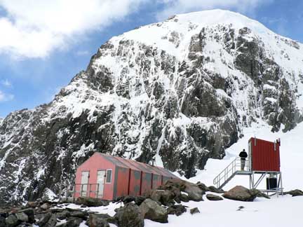 The Empress Hut with the great south face of Mount Hicks in the background and Bill entering the toilet.
From the hut I poked around the major ridge separating the hut from the Empress Shelf and had this great view of the Empress Shelf and Mount Cook's Low Peak on the right side of the photo. Our route would have taken us up the low point near the center of the photo.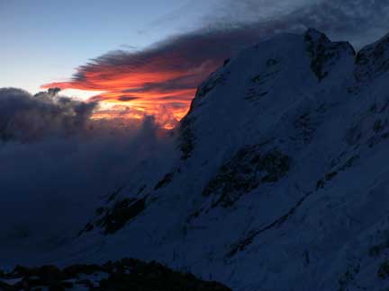 After dinner we sat back and watched the show! An amazing sunset looking down the Hooker Valley.At 2:45am our watch alarms sounded and we were up to a clear sky. It had actually frozen at our elevation and the temperature was 28 degrees. A slight wind was blowing. Bill and I headed out from the hut around 3:45am roped up. We first had to head down and slighty south to gain the lower Empress Shelf before heading up the shelf towards the Porter's Col just north of Low Peak. The morning started out nice but as we made progress up the shelf passing beside large gaping crevasses that looked very intimidating in the dark, clouds began to engulf us from the valley. The fog soon got very thick and we found ourselves on steepening terrain of about 50 degrees. It was fairly icy as well. 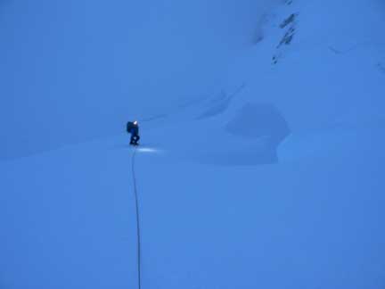 Ascending the lower Empress Shelf in the early morning.Following our tracks back in the fog and dark proved difficult requiring a great attention to detail. Bill started out and then I eventually took over the lead on the descent. We passed back by the gaping cracks and I was looking forward to getting back to the hut for breakfast and back down to the Gardiner Hut. Around 6:00am we arrived back at the hut still shrouded in a dense fog. Chris was still sleeping. Previous hut occupants had left a bunch of porridge so I began cooking that up for a nice hot breakfast. It sure hit the spot! After Chris awoke we began packing up. Then, quite suddenly, the fog disappeared and it was a perfect day! Naturally that would be the case since we had decided to bail on the climb. It always goes that way. Well, at least we'd be able to see our way back down the glacier for a change! A little after 10am we were roped up and descending the glacier with Chris in the lead. Walking past many of the large crevasses and holes in the glacier on our descent was surprising as we hadn't seen much during the ascent. It's almost better not to see those deep cracks! On our descent things heated up with the reflective heat of the glacier but the hiking was uneventful and we arrived back at the Gardiner Hut around 12:15pm. The sun was out and the sky clear and we were still damp from all the previous day's rain and snow. It sure felt good to lounge on the deck of the hut that afternoon while all our clothes and gear dried out! We debated hiking out that night but knew that finding a place to stay on Christmas Eve in the village would be expensive at best and improbable. Had we been able to see to the future we would have descended that afternoon. That night the wind and rain came in hard and continued into Christmas Day.
Sunday, December 25th
Around 10:30am we left the hut and started the rappels down the cables. As it turned out a couple of the rap anchors were smack in the middle of small waterfalls down the rock so we were soaked in no time flat.
 Rappelling down the cables route of Pudding Rock in the rain.After they both arrived on the snow I looked at leg and it wasn't good. I could see inside the leg and see that fatty looking tissue that's a sure indicator of a deep gash. I fished the first aid kit out of my pack and placed a band-aid over the wound. Just enough dressing to cover it until I could get out of the rain and into a safer location. We roped up for the short jaunt down the snow into the icefall where we unroped and starting following our trough back down through it. The going was a bit more efficient on the descent having been through this section once but we could see small changes in the ice that took place over a few days. We reached the end of the glacier uneventfully and then plowed through the moraine back towards the gully we needed to ascend up to the shelf on the east side of the valley above the lake. We were all soaked and our packs were all weighing a great deal more having been saturated with water by now. But our spirits were good once we reached the top of the gully and the good trail on the shelf above the lake. We'd soon be back in the village and would meet up with Allison at the YHA hostel where she was staying. A good dinner and some beer was also on our minds. Following the trail out we stayed on good trail all the way back to the trailhead. Bill and I managed to get a little ahead of Chris and as soon as we reached the trailhead I volunteered to head back into the village to try to find Allison and come back with the car to pick Bill and Chris up. I ran most of the nearly two miles back into the village but a nice couple from Seattle stopped and gave me a ride for the final .5 mile. They dropped me off at the YHA and as I was rounding the corner to the entrance I ran right into Allison! It was the perfect Christmas present! She was heading out for an evening hike and the timing was just impeccable! We drove back to the trailhead to pick up Bill and Chris and headed back to the YHA hostel. That night we made it in time for the big Christmas Dinner Buffet at the swanky Hermitage Hotel in the village (it was the only place open). The food was fantastic albeit expensive but we didn't care. The climb had been an awesome experience and we were all happy to be together on Christmas night enjoying the good company of friends over good food and drink! Merry Christmas! Written by Jason Halladay on 10 January 2006.
|