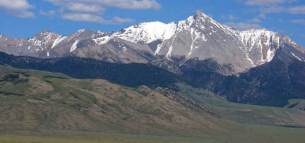
 Idaho's Highest Mountain-Borah Peak, Idaho (12,662')
Tuesday, July 5th After climbing Granite Peak, Montana the previous day, Bill, Erik and I had a relaxing day driving from our camp near Big Timber, MT through the towns of Salmon and Challis, ID to the Borah Peak trailhead off of Idaho Highway 93. En route to the trailhead we stopped for an early dinner in Challis and settled on the only cafe we could find on main street in town. The three of us all ate the exact same thing--chicken fried steak with mashed potatoes smothered in brown gravy. Delicious! This cafe had a nice salad bar and a friendly wait staff. Recommended indeed. We pulled into the trailhead area around 6pm to find 5 established but primitive campsites in the trailhead area. The best spot was a site covered by tall trees with lush grass for the tents. This site, however, was taken. The other sites all had picnic tables and fire pits but didn't offer much in the way of nice, flat tent spots. But one site had an extremely flat spot serving as the parking area for the campsite. That would do just fine. We pitched our tent in the site's parking area and parked right next to the tent. There is a nice restroom at the trailhead as well. Camping is free. Another few cars pulled up and we could easily recognize the "highpointers" t-shirts of two of the members of the group. We spoke briefly with a woman from the party of six about her plan. She had been up here last Fourth of July weekend and got skunked by early thunderstorms. They weren't going to risk it again and planned to start their hike the next day at 4am. We bid her good luck and enjoyed some beer and snack food in our little site until dusk when the mosquitos came out in full force. We tried to hold our ground and fight them off but soon retreated into the tent for an early bedtime. We had already packed our camelback packs and were ready for bed anyhow. We decided on a 4am wakeup call and hoped to be on the trail by 4:30am. We weren't terribly concerned about being caught in any thunderstorms (the forecast was for great weather) but had plans to meet a friend at City of Rocks, ID the next evening for three days of rock climbing on the beautiful granite outcrops there. We figured we'd be able to make the roundtrip hike in 8 or 9 hours based on reports we had read previously. Most notably we referenced Kevin Baker's report from a few weeks previous and were expecting some snow travel on "Chicken Out Ridge". Wednesday, July 6th We began stirring a bit after 4am and saw the party of 6 departing the trailhead adorned in headlamps. We hoped to dawdle a bit waiting for enough light to leave our headlamps in the car. After a quick banana and bagel breakfast we shouldered our very light packs (camelback packs with two liters of water, snacks, a rain shell, hat and ice ax) and hit the trail quick at 4:45am. 
Packed and ready to go! It still wasn't super light outside but the trail was good enough to see without our headlamps. The trail started out with a decent grade and soon steepened a great deal. All three of us felt good. We were wearing trail running shoes for footwear and with our light packs we were able to hold a very quick pace and within 35 minutes we politely passed the group of 6 that had set out 45 minutes ahead of us. They commented that the "sherpas had arrived" and jokingly requested us to take their packs. We gave the reply, "We'll carry them for beer", but the group did not accept our offer and we carried on. We soon broke out of treeline and had a great view down into the valley to the west. The view strongly reminded me of the view of the San Luis Valley from the Lake Como trail. Very cool. A glance at the watch showed that we had ascended 2,400 feet in an hour. Whew! Steep trails tend to be quite direct apparently. As the sun began to rise it conjured up a whole mess of mosquitos. We tried to stop for a quick snack but were getting attacked by mosquitos. It was the kind of attack where one shoulder smack yields a mosquito kill of at least 3. Again under attack we did the only natural thing--go higher (and go faster!). We soon passed by point 10,634' and were hiking efficiently along the relatively flat trail along the ridge for about a quarter mile. The trail then steepened again and we encountered the first bit of snow. 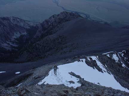
Bill ascending the ridge through the first snow patch we encountered. The snow didn't last too long and we did some class 3 scrambling for a bit before deciding we'd no longer need our hiking poles so we stashed them among some rocks. More class 3 scrambling lead to a short downclimb to a snowy ridge section. We took out our ice axes as the snow was still a bit icy. However, good steps in the snow made the crossing straight forward. Up and over another section of rock we found ourselves looking at a much longer, more exposed section of snow ridge. Again, though, good boot track in the snow made the crossing much easier than it could have been. 
Erik crossing the longest section of snow ridge. From there it was more class 3 scrambling to the prominent ridge point at 11,900'. And we were finally in the sun! We enjoyed the sun's warmth and lack of mosquitos for a few minutes before carrying on. From here we could see the rest of the route and we had clearly completed the most difficult portion of the ascent. The rest of the ridge looked like an enjoyable scramble on dry rock to the summit. We could see some old boot track in the snow on the west side well below the ridgecrest. Wearing only trail runners and looking at the fun 3rd class rock on the ridgecrest, the decision was simple. We danced, pranced, whistled and just enjoyed the ridge scrambling. 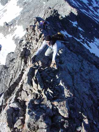
Bill and Erik having a great time. At one point I looked at my watch and realized that we were on course to make the summit in less than 3.5 hours. Motivated by this arbitrary goal, we got into a consistent scrambling rhythm and reached the top of Idaho at 8:14am--3 hours and 29 minutes after leaving the trailhead. 
Bill reaches the roof of Idaho! The weather was nearly perfect and the views of the other mountains in the Lost River Range were astonishing. These peaks just appear to jut sharply out of the surrounding valley. There was a summit register of sorts but it was merely an old ammo box with tons of scrap paper inside so we didn't bother. We did find a plastic tube that contained a wet, homemade flag that said, "Mount Borah". Man, someone carried that thing up here and didn't even get the name of the peak right! Poor sap. The three of us enjoyed a 40 minute break on the summit chatting about previous trips we'd done and how it came to be that we were climbing partners. A fun history lesson and certainly something to ponder. Would we be climbing as much or at this same level now had we not met and became such good friends and climbing partners? Life works in funny (but often great) ways. Deep mountain top conversation. But at nearly 10am we decided it was time to head down in pursuit of more climbing adventure together. We still could not see the group of six we passed on the way up though. Scrambling down the ridge went smoothly thanks to mostly solid rock. We met up with the group of six as they were reaching the 11,900' point. They were down to 4 at this point as "Chicken Out Ridge" had made its impression on two members of their party. We bid them a good morning and carried on. Reversing the class 3 ridge and snow ridges was easier as the snow had had time to soften up and had seen more traffic since we first went through. After retrieving our poles we motored along the ridge but stopped to look back up at the mountain summit once more. 
Looking up from 10,700' at the summit of Borah Peak (left) and the southwest ridge. The snow ridges of "Chicken Out Ridge" can be seen on the ridge in the right side of the photo. The steep trail descent wasn't joyful for the toes and quads but we took our time and picked our way down. We arrived back at the vehicle just before 11:30am making for a 6:39 roundtrip time. A time we were very pleased with on a very wonderful climb. Thank you Borah Peak. Written by Jason Halladay on 13 July 2005.
|